

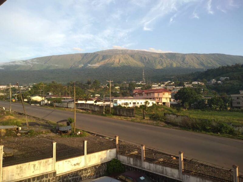
Mount Cameroon view from Buea, Cameroon. Image from Wikimedia Commons by . CC BY-SA 4.0
Clara Efande, a resident of Buea’s Bonduma neighborhood, arrived at her Church on Thursday for her weekly fellowship meeting, but quickly changed her plans after seeing a pool of black water surrounding the building. There had been flooding in some areas in Buea, capital of the South West region, and her church in Bokwai happened to be in one of those areas. Debris-ridden water covered the area from the tarred road to the slope where the wooden church sits. The flooding was not caused by rain but a fast-moving flow of water, volcanic ash, and debris known as a lahar, which descended from Mount Fako into nearby communities on Thursday, April 2, 2026, for the third time in six years.
Experts say lahars, mudflows made of volcanic material, occur because loose material on the slopes of an inactive but still changing volcano is washed down amid sudden rainfall after prolonged periods of dryness.
Located on the coast of the Gulf of Guinea, Buea, capital of the South West region of Cameroon, is home to the tallest mountain in West Africa, Mount Cameroon, also known as Mount Fako. The landscape rises to a height of 13,435 feet (4,095 meters). The town of Buea is on the southeastern slope of Mount Cameroon, and foot paths are created yearly for the annual Mount Cameroon Race of Hope.
A silent threat
Since its last eruption, which occurred in the year 2000, the volcano has been silent until inhabitants of the town witnessed a black burst of water rushing down on March 24, 2020, after a brief downpour of rain. This affected neighborhoods like Bonduma, Sandpit, Bokwai, Bokoko, Great Soppo, Buea Town, and Bokwango. Three years later, the March 18 lahar left two dead and four injured, directly affecting an estimated 900 people in Bova, Bokwai, and Buea Town neighborhoods, according to a 2023 report from the United Nations Office for the Coordination of Humanitarian Affairs. Before the population could comprehend this phenomenon, yet another one occurred in April this year.
This third incident, which came with little warning, halted mobility for hours. Pascaline Mupian recounted to Global Voices:
I could not return home as usual because there was flooding on my daily route. I waited for a while but when I noticed the intensity of the situation, I sought a different way to get home.
She also explained that she owns farmland, and this lahar runs just beside it, dumping bottles and other household waste, which could carry on the farmland. This increases her workload whenever she goes to the farm after a lahar because she has to start by picking up these items that destroy the soil’s fertility before continuing her farm work. Others are even less lucky and have to spend hours removing the water from their homes and doing a thorough clean-up afterward.
Those residing in affected neighborhoods report witnessing a change in the lahar flow in the most recent disaster. The water moved much faster and reached farther distances, causing flooding in far-off neighborhoods like Molyko, unlike on the first two occasions. Students of Bilingual Grammar School Molyko were even forced to move in the water, which had already spread through a good portion of the school. “There was no way I could walk from the chemistry Lab back to class without entering the water,” Faahnui Ghogomu, a student in the school, told Global Voices.
Origin of lahars
While many relate lahars to flash floods, experts argue that flash floods are driven by intense rainfall events that produce rapid runoff while lahars originate from loose volcanic deposits. According to experts, this pattern of lahars flowing at the start of the rainy season can be explained through interacting environmental processes, against a backdrop of a prolonged dry season. Pelagie Limunga, an environmentalist and Ph.D. research fellow from the University of Buea, told Global Voices:
These early rains often generate high surface runoff because the ground is initially unable to absorb water effectively. At the same time, dry-season weathering leaves behind lose volcanic sediments on slopes and in drainage channels, which are easily carried away by rain.
She refuted any indication of renewed volcanic activity, further describing lahars as “rainfall-driven remobilization of volcanic sediments rather than any form of eruptive reactivation.”
Limunga Pelagie also added that vulnerable areas in Buea are “strongly shaped by topography, and how human settlement patterns interact with natural drainage systems.” She stated that these areas are set along steep slopes and natural flow pathways descending from Mount Cameroon. They include communities like Buea Town, Bokwai, Bokoko, Great Soppo, Sandpit and Bova.
Authorities’ responses
Following the incident this year, the Regional Delegate of Scientific Research and Innovation for the South West, George Mafany Teke, called on residents to be calm, while describing the lahar flow as part of natural processes. He advised citizens to avoid building near waterways and to stay away from ravines during rainfall.
The National Observatory on Climate Change regularly publishes a nationwide 10-day Dekadal bulletin, projecting weather forecasts as per meteorological readings. On April 1, 2026, the 10-day bulletin published on their official Facebook page predicted flooding in the South West region, but the town of Buea was not listed among the potentially affected areas, according to their forecast. However, experts hold that several early indicators, such as unusually intense rainfall, rapid rise in stream flow, active erosion along hillsides, blocked drainage channels, and sudden discharge of muddy water from upland areas, can help predict potentially hazardous flow events. They emphasize that “community awareness of these indicators remains essential for early response.”
While the community grapples with the social and environmental repercussions of these violent flows, they are uncertain of the nature or intensity of the next lahar event, as experts reveal that future occurrences are highly likely to happen, based on current environmental and socio-spatial trends like “increasing rainfall variability, which contributes to more runoff events over shorter periods,” Pelagie Limunga explained. She added that urban expansion also contributes to this phenomenon.
Although hazard maps for landslides and slope risks in Buea exist, limited access, outdated data, and a lack of detailed neighborhood-level mapping mean many communities remain exposed, with risk information not fully revealing where and how people ought to build and prepare for disasters. There might be a ray of hope that lahars do not predict volcanic eruptions, but an even greater fear of the unknown lingers as vulnerable communities are not well informed, and more violent lahars are likely to occur in the coming years.